- Thumbnail
- Resource ID
- db49d4be-a085-11ed-91ab-0242ac140008
- Title
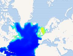
- Modeled Export POC Flux in period 1951 to 2000 under RCP85 for the deep Atlantic Ocean
- Date
- Jan. 28, 2023, 7:47 a.m., Publication
- Abstract
- The data layers provided show current values for seawater temperature, pH, calcite and aragonite saturation (%), oxygen concentration, and particulate organic carbon (POC) flux to the seafloor at different depths (500, 1000, 2000, 3000, and 4000m) at the present day (1951-2000) and changes in these variables expected between 2041-2060 and 2081-2100 under different RCP scenarios. The data layers were generated following the methods described in Levin et al. (2020). In short, in 2019, we obtained the present day and future ocean projections for the different years which were compiled from all available data generated by Earth Systems Models as part of the Coupled Model Inter-comparison Project Phase 5 (CMIP5) to the Fifth Assessment Report of the Intergovernmental Panel on Climate Change. Three Earth System Models, including GFDL‐ESM‐2G, IPSL‐CM5A‐MR, and MPI‐ESM‐MR were collected and multi-model averages of temperature, pH, O2 , export production at 100-m depth (epc100), carbonate ion concentration (co3), and carbonate ion concentration for seawater in equilibrium with aragonite (co3satarg) and calcite (co3satcalc) were calculated. The epc100 was converted to export POC flux at the seafloor using the Martin curve (Martin et al., 1987) following the equation: POC flux = export production*(depth/export depth)0.858. The export depth was set to 100 m, and the water depth using the ETOPO1 Global Relief Model (Amante and Eakins, 2008). Seafloor aragonite and calcite saturation were computed by dividing co3 by co3satarg and co3satcalc. All variableswere reported as the inter-annual mean projections between 1951-2000, 2041-2060, and 2081-2100. The data for calcite and aragonite saturation can be found in Morato et al. (2020). This layer contains only the Export POC Flux for period 1951 to 2000 which was extracted using gdal. The original data can be accessed at https://doi.org/10.1594/PANGAEA.944370.
- Edition
- --
- Owner
- Andrew.Sweetman
- Point of Contact
- clwei@ntu.edu.tw
- Purpose
- --
- Maintenance Frequency
- None
- Type
- not filled
- Restrictions
- None
- CC-BY-4.0: Creative Commons Attribution 4.0 International
- License
- Creative Commons Attribution 4.0 International
- Language
- eng
- Temporal Extent
- Start
- Jan. 1, 1951, midnight
- End
- Dec. 31, 2100, midnight
- Supplemental Information
- No information provided
- Data Quality
- The data set was checked for completeness, correctness, and consistency of metainformation. Validity of used methods was checked and - if applicable - precision and range of data.
- Extent
-
- x0: -98.000000000000000
- x1: 20.000000000000000
- y0: -50.000000000000000
- y1: 66.500000000000000
- Spatial Reference System Identifier
- EPSG:4326
- Keywords
- no keywords
- Category
- geoscientificInformation
- Regions
-
Global